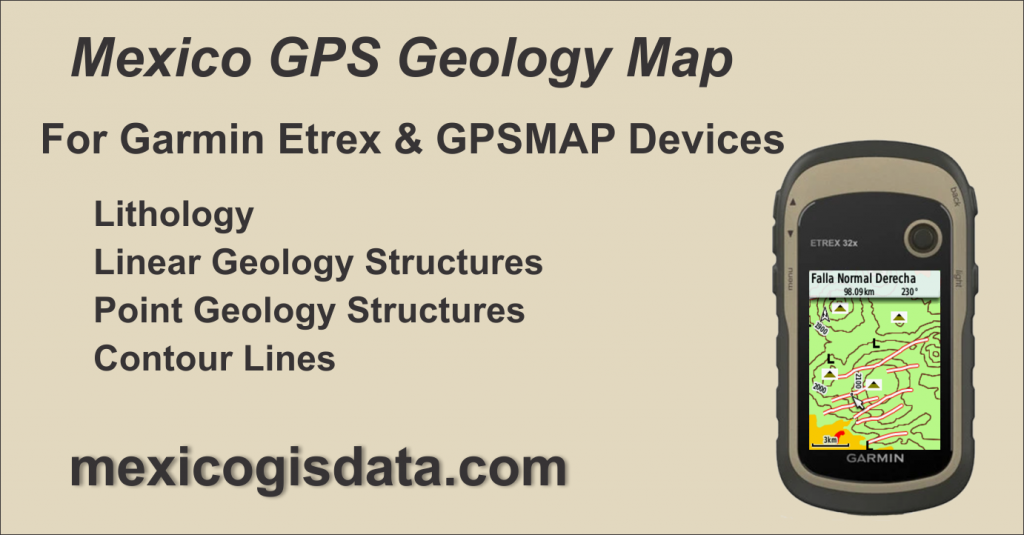
Mexico GPS Geological Map, Mexico’s geology in your Garmin Etrex and GPSMAP device.
Mexico GPS Geological Map is a conversion and adaptation of the 1:250,000 scale digital geological cartography issued by INEGI (https://www.inegi.org.mx/temas/geologia/) to a vector format compatible with Garmin Etrex and GPSMAP GPS device families, widely used in the professional field.
Contents
Lithology
Represented by polygons, a graphic representation based on colors was developed taking as reference the corresponding Era, Period and Geological Epoch, as well as the key of the corresponding rock type, as can be seen in these images.
| ERA | SYMBOL | COLOR |
|---|---|---|
| Cenozoic | Q | Greens and Yellows |
| Cenozoic | Ts | Greens and Yellows |
| Cenozoic | T | Greens and Yellows |
| Cenozoic | Te | Greens and Yellows |
| Cenozoic | Tpal | Greens and Yellows |
| Cenozoic | Tpl | Greens and Yellows |
| Cenozoic | Ti | Greens and Yellows |
| Cenozoic | Tom | Greens and Yellows |
| Cenozoic | Tm | Greens and Yellows |
| Cenozoic | To | Greens and Yellows |
| Mesozoic | K | Orange and Browns |
| Mesozoic | Ki | Orange and Browns |
| Mesozoic | Ks | Orange and Browns |
| Mesozoic | TR | Orange and Browns |
| Mesozoic | M | Orange and Browns |
| Mesozoic | Js | Orange and Browns |
| Mesozoic | Jm | Orange and Browns |
| Mesozoic | J | Orange and Browns |
| Mesozoic | Ji | Orange and Browns |
| Paleozoic | P | Maroon tones |
| Paleozoic | Ps | Maroon tones |
| Paleozoic | Pe | Maroon tones |
| Paleozoic | Pi | Maroon tones |
| Precambric | PE | Dark Maroon |
| Other | H2O | Blue |
| Other | S/It | Red |
| Other | JALES | Red |
| Other | Salina | Red |
Linear Geological Structures
- Contains the following items
- Sinkholes
- Structural Axes
- Tabular Structures
- Failures
- Fractures
- Klippe
- Alteration Zones
To which additional data was added such as Type, Horizontal Movement, Vertical Movement, Inclination and Dip, as applicable, achieving a clear identification of each of them.

Point Geological Structures
The following features are represented as points of interest on the Mexico GPS Geological Map:
- Stratus Attitude
- Pseudostratus Attitude
- Volcanic Apparatus
- Material Bank
- Oil field
- Dome
- Volcanic Flows
- Mine
- Verification Point
- Geothermal Zone
With aggregate data, as applicable, such as: Mineral (primary, secondary and tertiary in the case of mines), type, inclination and dip.

Contour Lines
As a topographic reference to facilitate the interpretation of the geological features that are part of this map.
Roads and Cities
Finally, it includes a layer of main roads throughout the country plus cities and towns represented by points to provide context for the location of geological features.
Mexico GPS Geological Map Features
Coverage of the entire country divided into 17 segments identified by zones following the classification used by INEGI as shown in this image

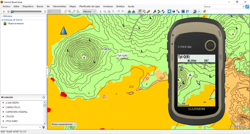
Compatible with Garmin Basecamp program through an installer for PC and from which the map is loaded into the GPS device.
Designed so that lithology and linear geological structures are displayed on the GPS device from a 3 km zoom when set to a Normal map detail level. Contour lines and point geological features appear at 800m zoom levels to avoid screen clutter.
By changing the GPS map detail level to Maximum, the lithology and linear geological structures will be shown from the 12km zoom and the contour lines and point geological features at the 3km zoom.
When hovering a feature that make up the map with the cursor in the GPS, the identification data will be displayed in the upper left part of the screen. Similarly in Basecamp, it will highlight a box with the item’s information.
The use of INEGI’s geological data is public in accordance to the “ACUERDO por el que se aprueba la Norma Técnica para el acceso y publicación de Datos Abiertos de la Información Estadística y Geográfica de Interés Nacional” (https://dof.gob.mx/nota_detalle.php?codigo=5374183&fecha=04/12/2014#gsc.tab=0) published in Diario Oficial de la Federación on December 4th, 2014.
Sample Map
A sample map is available for download so that you can try Mexico GPS Geological Map on your device as well as on Basecamp. This sample is located in the southern part of zone F-14, with the city of Querétaro as a reference.
You may download it from this link and follow the installation instructions described below. It is a file named MGDMuestraMineriaGeologia.rar that contains the installer named MGDMuestraMineriaGeologia.exe
Note: This sample map also shows mining data from our Mexico Mining Map that is not part of the Geological Map.
Acquisition and Installation Information
Price: 1,160.00 pesos per GPS Unit
$1,160.00Add to cart
From 6 to 10 maps in a single order 5% discount
11 or more maps in a single order 10% discount
Mexico GPS Geological Map is available as an Installer compatible with Basecamp on Windows from which it is sent to the GPS. It allows you to select between uploading the entire country or only those regions that are of interest.
Only available for Windows operating system. This installer is not compatible with the Mac platform.
Garmin’s Basecamp shall be already installed in your computer. It may be downloaded for free from Garmin’s website at https://www.garmin.com/es-MX/software/basecamp/
Activation code
In order to view and use the map on both Basecamp and GPS, an activation code is required. To issue your activation code you shall provide us with the GPS ID number in which the map will be used. The GPS ID is a 10-digit number that is a unique digital identifier for your GPS. There are two ways to get it:
With Basecamp
- Connect the GPS to PC and turn it on.
- Start Basecamp
- On the left side you will see the GPS model and its ID number
Directly from the GPS
Etrex models and GPSMAP series
- Turn on the GPS
- Go to the Settings menu (wrench icon)
- Select About
- The device ID appears at the top
Send us your GPS ID to generate the map activation code.
About the License
The indicated price grants a single license to be used on a single GPS device. An unlock code tied to the GPS ID will be issued allowing it to be viewed specifically on that device. This license is not transferable to another GPS device under any circumstances, including damage, theft or loss of the registered GPS device.
Return policy
Once the map unlock key is issued, returns are not accepted. Likewise, returns will not be accepted for errors or omissions in the cartographic and navigation information on land. In any case, the pertinent corrections will be made and sent to the user.
Invoicing
If an invoice under Mexican regulations is required, it must be requested at the time of placing the order, providing the corresponding fiscal data. We will not be able to generate an invoice if it is not requested simultaneously with the order.
The acquisition, installation and/or use of this map is considered as an acceptance of the exposed terms.
Memory requirements and compatibility
The size of the entire map is 424 Mb. It is compatible with Garmin GPS devices capable of using maps, is compatible with Basecamp and have sufficient memory capacity to accept the map files, either in internal memory or through a card.
Installation and Unlocking
Follow our Installation and Unlocking instructions for Mexico GIS data mapping products.