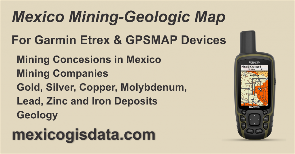
Mexico Mining Map for GPS gathers Mexico’s mining industry information in a format compatible with Garmin’s eTrex GPS and GPSMAP family.
Mexico Mining Map for GPS is a conversion and adaptation of digital cartography from various sources within the Open Data (Datos Abiertos) scheme to a vector format compatible with Garmin eTrex and GPSMAP GPS device families, widely used in the professional field.

Contents
Mexico Mining Map for GPS is a Mining-Geological map focused on the Mining Industry of Mexico that is made up of:
Mining Concessions
It contains 24,723 mining concessions issued by the Ministry of Economy (Secretaria de Economia), representing them as points at the center of the concession area, as well as its limits represented as lines in which the name of the area was integrated to facilitate location when using GPS. The source data was kept as is, just adding the word “Mina” before the name to facilitate its search on the device.

Mining Companies
Taken from the DENUE data base as of May 2022, the 3,142 mining companies were integrated to the map. As in the previous case, the word “Mina” was added in order to facilitate searches on the device.


Mining Deposits
Mining deposits were added considering two information sources:
Between the years 1995 and 2005, Geochemical Analyzes of content in active sediment samples from streams were carried out and are published by the Mexican Geological System. According to the information published by SGM, data was collected by percentiles of 31 elements that are Ag (Silver), Al (Aluminum), As (Arsenic), Au (Gold), Ba (Barium), Be (Beryllium), Bi ( Bismuth), Ca (Calcium), Cd (Cadmium), Co (Cobalt), Cr (Chromium), Cu (Copper), Fe (Iron), Ga (Gallium), K (Potassium), Mg (Magnesium), Mn ( Manganese), Mo (Molybdenum), Na (Sodium), Ni (Nickel), P (Phosphorus), Pb (Lead), Sb (Antimony), Sc (Scandium), Se (Selenium), Sn (Tin), Sr ( Strontium), Te (Tellurium), Tl (Thallium), U (Uranium), W (Wolframium) and Zn (Zinc) in 47,098 sampling points distributed throughout the country.
Each sampling point contains the data of the analyzed elements, as well as a denomination composed of its location within the INEGI 1:250,000 chart nomenclature system plus a consecutive number assigned to the point within the chart. Combining both, a unique identification is obtained for each one of them.
Also, the Ministry of Economy publishes a document called “Mining Targets” available at https://www.economia.gob.mx/files/gobmx/mineria/targets_mineros.pdf in which the minerals considered as the best investment opportunity are listed as follows:
- Gold (Au) and Silver (Ag)
- Copper (Cu) and Molybdenum (Mo)
- Lead (Pb) and Zinc (Zn)
- Iron (Fe)
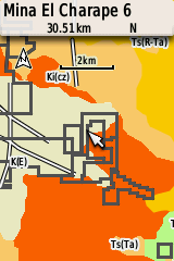
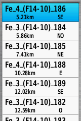
For this map creation, these 7 elements were integrated as points of interest so that they can be searched on the device using a nomenclature system based on Geochemical Analysis as follows:
[Chemical Element]_[Chemical Analysis Measurement Unit]_(Chart Number)_Consecutive
Resulting in this configuration
Fe_4_(F14-10)_186
where:
- Fe is the chemical element, Iron in this example
- The 4 is the unit of measure obtained in chemical analysis, which is 4% in this example. Allows to identify richer deposits for the element.
- (F14_10) is the INEGI chart where this sampling point is located
- 186 is the consecutive number assigned in letter H13_10 to the sampling point.

Using this nomenclature, it is possible to search for deposits by element and by chart as shown in these images corresponding to a GPSMAP 65


Geology
It contains the same information from our Mexico GPS Geological Map, which was used as a starting point for this development. Please refer to the linked page for further details on its contents.
Roads and Cities
Layers with main roads throughout the country plus cities and towns represented as points to provide context for the location of mining features.
Data Sources
The following data sets were obtained from Mexico’s Open Data Platform:
Mining Cartography from the Ministry of Economy (Secretaria de Economia)
https://www.datos.gob.mx/busca/dataset/cartografia-minera-de-se
Geochemical Cartography 1:250,000 scale published by SGM (Sistema Geologico Mexicano)
https://www.datos.gob.mx/busca/dataset/cartografia-geoquimica-escala-1-250000
as well as INEGI’s DENUE data under the Open Data Standard at
https://www.inegi.org.mx/app/descarga/
Mexico Mining GPS Map Features
Coverage of the entire country divided into 17 segments identified by zones following the classification used by INEGI as shown in this image

Compatible with Garmin Basecamp program through an installer for PC and from which the map is loaded into the GPS device.
Designed so that mining data is displayed on the GPS device from a 3 km zoom when set to a normal map detail level.
By changing the GPS map detail level to Maximum, the mining data will be shown from the 12km zoom.
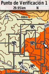
When hovering a feature that make up the map with the cursor in the GPS, the identification data will be displayed in the upper left part of the screen. Similarly in Basecamp, it will highlight a box with the item’s information.
Sample Map
A sample map is available for download so that you can try Mexico GPS Geological Map on your device as well as on Basecamp. This sample is located in the southern part of zone F-14, with the city of Querétaro as a reference.
You may download it from this link and follow the installation instructions described below. It is a file named MGDMuestraMineriaGeologia.rar that contains the installer named MGDMuestraMineriaGeologia.exe
Acquisition and Installation Information
Price: 1,160.00 pesos includes VAT
Mexico Mining GPS Map is available as an Installer compatible with Basecamp on Windows from which it is sent to the GPS. It allows you to select between uploading the entire country or only those regions that are of interest.
Only available for Windows operating system. This installer is not compatible with the Mac platform.
Garmin’s Basecamp shall be already installed in your computer. It may be downloaded for free from Garmin’s website at https://www.garmin.com/es-MX/software/basecamp/
Activation code
In order to view and use the map on both Basecamp and GPS, an activation code is required. To issue your activation code you shall provide us with the GPS ID number in which the map will be used.
The GPS ID is a 10-digit number that is a unique digital identifier for your GPS.
There are two ways to get your GPS ID:
With Basecamp
- Connect the GPS to PC and turn it on.
- Start Basecamp
- On the left side you will see the GPS model and its ID number
DIRECTLY FROM GPS
Etrex models and GPSMAP series
- Turn on the GPS
- Go to the Settings menu (wrench icon)
- Select About
- The device ID appears at the top
Send us your GPS ID to generate the map activation code.
License
The indicated price grants a single license to be used on a single GPS device. An unlock code tied to the GPS ID will be issued allowing it to be viewed specifically on that device. This license is not transferable to another GPS device under any circumstances, including damage, theft or loss of the registered GPS device.
Return policy
Once the map unlock key is issued, returns are not accepted. Likewise, returns will not be accepted for errors or omissions in the cartographic and navigation information on land. In any case, the pertinent corrections will be made and sent to the user.
Billing
If an invoice is required, it must be requested at the time of placing the order, providing the corresponding fiscal data.
We will not be able to generate an invoice if it is not requested simultaneously with the order.
The acquisition, installation and/or use of this map is considered as an acceptance of the exposed terms.
Memory requirements and compatibility
The size of the entire map is 438 Mb. It is compatible with Garmin GPS devices capable of using maps, is compatible with Basecamp and have sufficient memory capacity to accept the map files, either in internal memory or through a card.
Installation and Unlocking
Follow our Installation and Unlocking Instructions for Mexico GIS data mapping products