This tutorial introduces Important GPS Concepts that are used in Field Surveys with Garmin GPS devices, allowing a better understanding of the processes used.
What does GPS do?
The basic function of a GPS device is to determine your location on the surface of the earth. It does so by receiving the signal from at least 4 satellites from one of the currently available constellations. Access to these signals is free of charge.
By receiving and processing at least 4 satellites, a very exact location is obtained both on the horizontal plane, that is, the surface of the earth, and the vertical plane, that is, the height above sea level. The way the computed position is displayed is by means of a coordinate system.
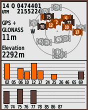
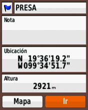
A basic GPS location consists of 2 elements, its geographical coordinates and the altitude above sea level, as you can see in this image
The best-known coordinate system is the Latitude and Longitude system, but there are others that have various advantages and applications, such as the UTM and MGRS systems.
Using the device’s software, these locations can be turned into waypoints, recorded tracks, or let it guide you to a specific location.
In the early days of using GPS devices, built-in maps were not available, so it was necessary to get the device’s coordinates and transfer them to a paper map to know where it was on the earth’s surface.
Today, with the availability of digital maps built into devices, as well as the option to add them from other sources, it will rarely be necessary to translate coordinates onto a paper map.
There are two types of maps that can be viewed on a GPS. Vector maps are the commonly used type and raster type that are images that can be customized and developed by the user. This allows you to view orthophotos, aerial photography or other types of custom maps, such as a DRG shown in this image
Initially, only the United States satellite system was available, named Global Positioning System whose acronym is GPS, which became popular as a generic reference name. Today there are several constellations of additional satellites launched and operated by other governments and that, depending on the model of your GPS, are accessible through its configuration parameters.
All the available systems as a group are known as Global Navigation Satellite System or GNSS and they are:
GPS
Developed by the United States military, it is the original global positioning system and has coverage for the entire world.
Being a military system, initially the accuracy for civil use was not good, in a range of 200 to 300 meters, since an intentional degradation called “Selected Availability” was used. In May 2000, this degradation was eliminated, which allowed us to obtain the precision that we have today.
GLONASS
Developed by Russia, it was the second GNSS available for civil use also with a high degree of accuracy. As in the case of GPS, its development was for military purposes and it offers coverage throughout the world.
GALILEO
Developed by the European Union, it is a GNSS for civil use exclusively and with the intention of avoiding its dependence on systems from other countries. Also, with worldwide coverage.
BEIDOU
It is the latest, developed by China and functional as of 2020, there are already some devices that also connect to this GNSS.
QZSS
4-satellite system to improve GNSS availability in Japan and surrounding areas of Asia. Only available in that region.
In addition to the GNSS mentioned, there are additional satellite systems whose role is to increase accuracy in certain parts of the world. Initially focused on aviation, they are also widely used in other fields.
These systems are:
- WAAS for North America
- EGNOS for Europe
- MSAS in parts of Japan and Asia.
In Garmin devices, you can choose to get the signal from more than one GNSS, as well as from the additional systems, resulting in increased lock up speeds and improving its accuracy.
At the time of writing this guide, eTrex devices can access GPS and GLONASS and GPSMAP 65 series devices can connect to GPS, GLONASS, Galileo, and QZSS (Japan region only).
Transmission Bands
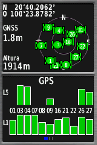
The signals that the GNSS satellites broadcast use different frequencies known as Bands. Initially, the one known as L1 was used and later a higher frequency one known as L2 was incorporated. Recently the use of the L5 began. Without getting into the complexities, the more bands a device can receive, the better its ability to get signals from satellites and increase accuracy.
GPSMAP 65 series devices are multiband as shown in this Satellite screen capture.
Waypoints, Tracks and Routes
After you get a GPS fix, there are 3 types of basic usage you can do.
The first is to save the location into the device’s memory creating what is known as a Waypoint consisting in:
- A symbol
- A name
- Location coordinates
- Height
- Note (optional)
which will remain in memory unless the user deletes it.

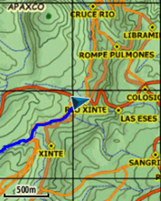
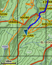
Second, the device will obtain positions as you move, showing it on the map. In this way you can know where you started a route, as well as the path followed. In this image the blue line represents the path followed and the triangular icon shows the current GPS location.
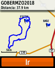
By saving this path in the GPS memory, a Track is created to which a name is given and its total length is recorded.
Third, is to ask the device to guide you to a specific destination such as a Waypoint, or following a previously saved Track, either in the same direction as it was originally recorded or in reverse, creating what is known as a Route.
Although the these three types of data was originally designed for recreational use, they have applications in business to capture features in the field and be able to transfer them to a Geographic Information System environment.